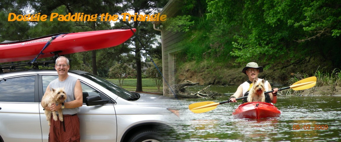
This all started on Memorial Day 2004 with the purchase of a Wilderness Systems Pungo 120.  I previously had a Mohawk 15XL canoe, which I used during my days in the Boy Scouts with my two sons.  But as all good things must end, they grew up and the good old canoe sat in the garage picking up dust. Since it was a two person canoe and I thought it might be neat to take my dog paddling, I ended up with the Pungo 120 since it had such a large cockpit. Take a Look!

So paddling away we go and on one paddling trip I got lost.  Ended up a kind fisherman guided me back to the Eno River Boat Ramp just before sunset.  So this exciting event ended up for me as a new Garmin 60CS GPS for Christmas.  And with that, the idea of making a web page for all this paddling stuff.  Now you can see some pictures and get the track for the trip to use in your own GPS.  So, here is the stuff...


It was a great run Maggie!    Maggie Tribute


Links:

    Triangle Meetup Kayaking Group    Carolina Kayak Club    Carolina Canoe Club    Paddling.net Discussion Forum   
    SandyBottom's Sea Kayaking and Other Adventures   Freya Hoffmeister  Get Going NC!
 

       All Put-ins(Google: My Maps)     Latest Trip    Lake Levels  Wind Map

 Equipment   Tent Alarm

Note: Click on 'MapIt' below in the 'Description' and this will show a Google Map of the Put In.  You can then click on the 'Get directions' tab and put in your address for directions to the Put In.   Also, the 'Hot Spots' for each major lake can be used to see a map with red stars which can be clicked on for information on that area of the lake.  The 'GPS Track' is now using GISsurfer a general purpose web map based on the free open-source Leaflet map API to display the GPS data.

Paddling Trips by Place and Date

Falls Lake : Hot Spots                                                                                        Total Paddling Miles : 640.3

A very interesting book on Falls Lake: The Battle For Falls Lake

Date Description GPS Track GPS Data
10/14-10/15 2014 Falls Lake - Holly Point XII FallsLakeHollyPointXIITrack FallsLakeHollyPointXIIGPS.gdb
10/9-10/10 2014 Falls Lake - Holly Point XI FallsLakeHollyPointXITrack FallsLakeHollyPointXIGPS.gdb
9/18-9/19 2014 Falls Lake - Holly Point X FallsLakeHollyPointXTrack FallsLakeHollyPointXGPS.gdb
7/16-7/17 2014 Falls Lake - Holly Point IX FallsLakeHollyPointIXTrack FallsLakeHollyPointIXGPS.gdb
5/14-5/15 2014 Falls Lake - Holly Point VIII FallsLakeHollyPointVIIITrack FallsLakeHollyPointVIIIGPS.gdb
8/25/2013 Falls Lake - Dam Area IV FallsLakeDamAreaIVTrack FallsLakeDamAreaIVGPS.gdb
6/15/2013 Falls Lake - Eno River Boat Ramp FallsLakeEnoRiverBoatRampTrack FallsLakeEnoRiverBoatRampGPS.gdb
4/14/2013 Falls Lake - Bluejay Point C5 FallsLakeC5BlueJayPointTrack FallsLakeC5BlueJayPointGPS.gdb
11/11/2012 Falls Lake - Raven Ridge Rd to Upper Barton Crk  Mapit FallsLakeRavenRidgeUpperBartonTrack FallsLakeRavenRidgeUpperBartonGPS.gdb
6/15/2012 Falls Lake - Ledge Rock IX  Mapit FallsLakeLedgeRockIXTrack FallsLakeLedgeRockIXGPS.gdb
6/3-6/4 2011 Falls Lake - Holly Point VII  Mapit FallsLakeHollyPointVIITrack FallsLakeHollyPointVIIGPS.gdb
5/27/2012 Falls Lake - Flat River II  Mapit FallsLakeFlatRiverIITrack FallsLakeFlatRiverIIGPS.gdb
11/21/2011 Falls Lake - Forest Ridge Park  Mapit FallsLakeForestRidgeParkTrack FallsLakeForestRidgeParkGPS.gdb
11/12/2011 Falls Lake - Canoeing  Mapit FallslakeCanoeingTrack FallsLakeCanoeingGPS.gdb
11/8/2011 Falls Lake - 13 Miler  Mapit FallsLake13MilerTrack FallsLake13MilerGPS.gdb
10/30/2011 Falls Lake - Mangus House  Mapit FallsLakeMangusHouseTrack FallsLakeMangusHouseGPS.gdb
10/23/2011 Falls Lake - Fall 2011  Mapit FallsLakeFall2011Track FallsLakeFall2010GPS.gdb
6/31/2011 Falls Lake - Ledge Rock VIII  Mapit FallsLakeLedgeRockVIIITrack FallsLakeLedgeRockVIIIGPS.gdb
6/7/2011 Falls Lake - Lower Barton Crk  Mapit FallsLakeLowerBartonCrkTrack FallsLakeLowerBartonCrkGPS.gdb
4/23/2011 Falls Lake - Half Marathon II  Mapit FallsLakeHalfMarathonIITrack FallsLakeHalfMarathonIIGPS.gdb
11/22/2010 Falls Lake - Half Marathon  Mapit FallsLakeHalfMarathonTrack FallsLakeHalfMarathonGPS.gdb
11/14/2010 Falls Lake - Zeagle's Rock  Mapit FallslakeZeaglesRockTrack FallsLakeZeaglesRockGPS.gdb
10/3/2010 Falls Lake - Nicole  Mapit FallsLakeNicoleTrack FallsLakeNicoleGPS.gdb
8/29/2010 Falls Lake - Eno River II  Mapit FallsLakeEnoRiverIITrack FallsLakeEnoRiverIIGPS.gdb
5/26/2010 Falls Lake - Ledge Rock VII  Mapit FallsLakeLedgeRockVIITrack FallsLakeLedgeRockVIIGPS.gdb
5/16-5/17 2010 Falls Lake - Holly Point VI  Mapit FallsLakeHollyPointVITrack FallsLakeHollyPointVIGPS.gdb
3/21/2010 Falls Lake - Spring  Mapit FallsLakeSpringTrack FallsLakeSpringGPS.gdb
2/21/2010 Falls Lake - 256ft  Mapit FallsLake256ftTrack FallsLake256ftGPS.gdb
1/17/2010 Falls Lake - 2010!  Mapit FallsLake2010!Track FallsLake2010!GPS.gdb
11/29/2009 Falls Lake - Laurel Creek  Mapit FallsLakeLaurelCrkTrack FallsLakeLaurelCrkGPS.gdb
11/16/2009 Falls Lake - Ida!2  Mapit FallsLakeIda!2Track FallsLakeIda!2GPS.gdb
11/15/2009 Falls Lake - Ida!  Mapit FallsLakeIda!Track FallsLakeIda!GPS.gdb
11/9/2009 Falls Lake - Dam Area III  Mapit FallsLakeDamAreaIIITrack FallsLakeDamAreaIIIGPS.gdb
9/3/2009 Falls Lake - Shakedown  Mapit FallsLakeShakedownTrack FallsLakeShakedownGPS.gdb
8/12/2009 Falls Lake - Perseids  Mapit Forgot to turn on the track log Forgot to turn on the track log
7/14/2009 Falls Lake - Old Weaver Trail  Mapit FallsLakeOldWeaverTrailTrack FallsLakeOldWeaverTrailGPS.gdb
6/30/2009 Falls Lake - Half Moon  Mapit FallsLakeHalfMoonTrack FallsLakeHalfMoonGPS.gdb
6/22/2009 Falls Lake - New Moon  Mapit FallsLakeNewMoonTrack FallsLakeNewMoonGPS.gdb
5/21/2009 Falls Lake - Night Run  Mapit FallsLakeNightRunTrack FallsLakeNightRunGPS.gdb
4/4 4/5 2009 Falls Lake - Holly Point V  Mapit FallsLakeHollyPointVTrack FallsLakeHollyPointVGPS.gdb
3/22/2009 Falls Lake - New Light Crk  Mapit FallsLakeNewLightCrkTrack FallsLakeNewLightCrkGPS.gdb
3/8/2009 Falls Lake - Hwy 50 Redux  Mapit FallsLakeHwy50ReduxTrack FallsLakeHwy50ReduxGPS.gdb
11/28/2008 Falls Lake - Ellerbee Creek  Mapit FallsLakeEllerbeeCrkTrack FallsLakeEllerbeeCrkGPS.gdb
9/14/2008 Falls Lake - BDFM  Mapit FallsLakeBDFMTrack FallsLakeBDFMGPS.gdb
9/13/2008 Falls Lake - Hanna2!  Mapit FallsLakeHanna2Track FallsLakeHanna2!GPS.gdb
9/7/2008 Falls Lake - Hanna!  Mapit FallsLakeHanna!Track FallsLakeHanna!GPS.gdb
7/15/2008 Falls Lake - Ledge Rock VI  Mapit FallsLakeLedgeRockVITrack FallsLakeLedgeRockVIGPS.gdb
7/1/2008 Falls Lake - Mid-Summer-Night  Mapit FallsLakeMidSummerNightTrack FallsLakeMidSummerNightGPS.gdb
6/18/2008 Falls Lake - Full Moon Jere  Mapit FallsLakeFullMoonJereTrack FallsLakeFullMoonJereGPS.gdb
5/19/2008 Falls Lake - Full Moon  Mapit FallsLakeFullMoonTrack FallsLakeFullMoonGPS.gdb
5/17/2008 Falls Lake - Knap of Reeds Crk II  Mapit FallsLakeKnapReedsCrkIITrack FallsLakeKnapReedsCrkIIGPS.gdb
5/10/2008 Falls Lake - The Zoo  Mapit FallsLakeTheZooTrack FallsLakeTheZooGPS.gdb
4/9/2008 Falls Lake - Search and Rescue  Mapit FallsLakeSearchRescueTrack FallsLakeSearchRescueGPS.gdb
12/9/2007 Falls Lake - Lawrence Cemetery  Mapit FallsLakeLawrenceCemeteryTrack FallsLakeLawrenceCemeteryGPS.gdb
11/21/2007 Falls Lake - Old Six Forks Bridge  Mapit FallsLakeSixForksBridgeTrack FallsLakeSixForksBridgeGPS.gdb
10/14 10/15 2007 Falls Lake - Holly Point IV  Mapit FallsLakeHollyPointIVTrack FallsLakeHollyPointIVGPS.gdb
9/25/2007 Falls Lake - Beaverdam VI  Mapit FallsLakeBeaverdamVITrack FallsLakeBeaverdamVIGPS.gdb
8/12/2007 Falls Lake - Ledge Rock V (Perseids)  Mapit FallsLakeLedgeRockVTrack FallsLakeLedgeRockVGPS.gdb
7/21/2007 Falls Lake - Ledge Rock IV (Sunset)  Mapit FallsLakeLedgeRockIVTrack FallsLakeLedgeRockIVGPS.gdb
6/21/2007 Falls Lake - Little River  Mapit FallsLakeLittleRiverTrack FallsLakeLittleRiverGPS.gdb
5/26/2007 Falls Lake - Upper Barton Creek V (Sunset)  Mapit FallsLakeUpperBartonCrkVTrack FallsLakeUpperBartonCrkVGPS.gdb
5/07/2007 Falls Lake - Flat River  MapIt FallsLakeFlatRiverTrack FallsLakeFlatRiverGPS.gdb
12/16/2006 Falls Lake - Highway 50 III  MapIt FallsLakeHwy50IIITrack FallsLakeHwy50IIIGPS.gdb
11/26/2006 Falls Lake - Eno Boat Ramp Flooded  MapIt FallsEnoBoatFloodedTrack FallsEnoBoatFloodedGPS.gdb
11/19/2006 Falls Lake - Highway 98 Fishing Access II  MapIt FallsHwy98FishAccessIITrack FallsHwy98FishAccessIIGPS.gdb
11/9/2006 Falls Lake - Hickory Hill IV  MapIt FallsLakeHickoryHillIVTrack FallsLakeHickoryHill4.gdb
9/3/2006 Falls Lake - Ledge Rock III  MapIt FallsLakeLedgeRockIIITrack FallsLakeLedgeRockIIIGPS.gdb
7/30/2006 Falls Lake - Eno River IV  MapIt FallsLakeEnoRiverIVTrack FallsLakeEnoIVGPS.gdb
7/23/2006 Falls Lake - Lick Creek II  MapIt FallsLakeLickCrkIITrack FallsLakeLickCrkIIGPS.gdb
6/17/2006 Falls Lake - Dam Area II  MapIt FallsLakeDamAreaIITrack FallsDamAreaII.gdb
6/10/2006 Falls Lake - Upper Barton Creek IV (Sunset/Full Moon)  MapIt FallsUpperBartonCrkIVTrack FallsLakeUpperBartonCrkIVGPS.gdb
4/28 4/29 2006 Falls Lake - Holly Point III  MapIt FallsLakeHollyPointIIITrack FallsHollyPointIIIGPS.gdb
3/23/2006 Falls Lake - Knapp of Reeds Creek  MapIt FallsLakeKnappReedsCrkTrack FallsKnappReedsGPS.gdb
3/11/2006 Falls Lake - WaterFord Creek II  MapIt FallsLakeWaterfordCrkIITrack FallsLakeWaterfordCrkII.gdb
1/1/2006 Falls Lake - Waterfork Creek  MapIt FallsLakeWaterforkCrkTrack FallsWaterforkCrkGPS.gdb
12/4/2005 Falls Lake - Highway 50 II  MapIt FallsLakeHwy50IITrack FallsLakeHwy50II.gdb
11/6/2005 Falls Lake - Highway 98 Fishing Access  MapIt FallsLakeHwy98Track FallsLakeHwy98GPS.gdb
10/31/2005 Falls Lake - Beaverdam V  MapIt FallsLakeBeaverdamVTrack BeaverdamVGPS.gdb
10/16/2005 Falls Lake - Hickory Hill III  MapIt FallsLakeHickoryHill3Track HickoryHill3.gdb
9/25/2005 Eno River Boat Ramp to Falls Lake IV  MapIt EnoFallsLakeIVTrack EnoRiverFallsLakeIVGPS.gdb
9/17/2005 Falls Lake - Upper Barton Creek III (Sunset/Full Moon)  MapIt FallsUpperBartonCrkIIITrack UpperBartonCrkIIIGPS.gdb
9/9 9/10 2005 Falls Lake - Holly Point II  MapIt FallsLakeHollyPointIITrack HollyPointIIGPS.gdb
9/05/2005 Falls Lake - Lick Creek  MapIt FallsLakeLickCreekTrack FallsLakeLickCreekGPS.gdb
8/19/2005 Falls Lake - Upper Barton Creek II (Sunset/Full Moon)  MapIt FallsUpperBartonCrkIITrack FallsLakeUpperBartonCrkII.gdb
8/13/2005 Falls Lake - Ledge Rock II (Sunrise)  MapIt FallsLakeLedgeRockIITrack LedgeRockIIGPS.gdb
7/24/2005 Falls Lake - Dam Area  MapIt FallsLakeDamAreaTrack FallsLakeDamArea.gdb
7/17/2005 Falls Lake - Rolling View II  MapIt FallsLakeRollingViewIITrack RollingViewIIGPS.gdb
6/4/2005 Eno River Boat Ramp to Falls Lake III  MapIt EnoFallsLakeIIITrack EnoFallsLakeIIIGPS.gdb
5/29/2005 Falls Lake - Purnell Road II  MapIt PurnellRoadIITrack PurnellRoadIIGPS.gdb
5/14 5/15 2005 Falls Lake - Holly Point  MapIt HollyPointAllTrack HollyPointGPS.gdb
5/7/2005 Falls Lake - Old 98 Road  MapIt Old98RdTrack Old98GPS.gdb
4/17/2005 Falls Lake - Possum Track Road  MapIt PossumTrackRdTrack PossumTrackRdGPS.gdb
4/6/2005 Falls Lake - Raven Ridge Road to Dam II  MapIt RavenRidgeDamIITrack RavenRidgeDamIIGPS.gdb
2/6/2005 Beaverdam IV  MapIt BeaverdamIVTrack BeaverdamIVGPS.gdb
1/1/2005 Eno River Boat Ramp to Falls Lake  MapIt EnoFallsLakeTrack EnoFallsLakeGPS.gdb
12/8/2004 Falls Lake - Raven Ridge Road to Dam  MapIt FallsRavenRidgeRdtoDamTrack  
12/5/2004 Falls Lake - Highway 50  MapIt FallsHighway50Track  
11/28/2004 Falls Lake - Rolling View  MapIt FallsRollingViewTrack  
11/22/2004 Falls Lake - Hickory Hills II  MapIt FallsHickoryHillsIITrack  
11/20/2004 Falls Lake - Hickory Hills  MapIt FallsHickoryHillsTrack  
11/7/2004 Falls Lake -Bluejay Point(Michael)  MapIt FallsBlueJayPointMichaelTrack  
10/31/2004 Falls Lake - Upper Barton Creek  MapIt FallsUpperBartonCreekTrack  
10/17/2004 Falls Lake - Eno & Flat  MapIt FallsEnoFlatTrack  
9/12/2004 Falls Lake - Purnell Road  MapIt FallsPurnellRoadTrack  
9/3/2004 Falls Lake - Eno River  MapIt EnoRiverTrack  
8/22/2004 Falls Lake - Ledge Rock  MapIt FallsLedgeRockTrack  
8/7/2004 Falls Lake - BW Wells  BWWellsTrack  
7/16/2004 Beaverdam III - Saving the Turtle See Beaverdam IV  
7/2/2004 Beaverdam II See Beaverdam IV  
6/12/2004 Falls Lake - Bluejay Point  MapIt FallsBluejayPointTrack  
6/6/2004 Beaverdam See Beaverdam IV  

Jordan Lake : Hot Spots                                                                                       Total Paddling Miles : 298.7

Date Description GPS Track GPS Data
10/9 10/10 2011 Jordan Lake - Parkers Creek  Mapit JordanLakeParkersCreekTrack JordanLakeParkersCreekGPS.gdb
6/14/2011 Jordan Lake - Poe's Ridge III  Mapit JordanLakePoe'sRidgeIIITrack JordanLakePoe'sRidgeIIIGPS.gdb
8/21/2010 Jordan Lake - Cub Creek II  Mapit JordanLakeCubCreekIITrack JordanLakeCubCreekIIGPS.gdb
7/2/2010 Jordan Lake - Robeson Crk III  Mapit JordanLakeRobesonCrkIIITrack JordanLakeRobesonCrkIIIGPS.gdb
10/11/2009 Jordan Lake - Bush Creek IV  Mapit JordanLakeBushCreekIVTrack JordanLakeBushCreekIVGPS.gdb
6/6/2009 Jordan Lake - Little Beaver Crk III  Mapit JordanLakeLittleBeaverCrkIIITrack JordanLakeLittleBeaverCrkIIIGPS.gdb
5/30 5/31 2009 Jordan Lake - New Hope Overlook III  Mapit JordanLakeNewHopeOverlookIIITrack JordanLakeNewHopeOverlookIIIGPS.gdb
9/1/2008 Jordan Lake - Robeson Crk II  Mapit JordanLakeRobesonCrkIITrack JordanLakeRobesonCrkIIGPS.gdb
5/26/1008 Jordan Lake - Little Creek II  Mapit JordanLakeLittleCrkIITrack JordanLakeLittleCrkGPS.gdb
4/27/2008 Jordan Lake - Little Creek  Mapit JordanLakeLittleCreekTrack JordanLakeLittleCrkGPS.gdb
3/14/2008 Jordan Lake - Northeast Crk II  Mapit JordanLakeNortheastCrkIITrack JordanLakeNortheastCrkIIGPS.gdb
11/5/2007 Jordan Lake - Morgan Creek II  Mapit JordanLakeMorganCrkIITrack JordanLakeMorganCrkIIGPS.gdb
11/1/2007 Jordan Lake - New Hope Overlook II  Mapit JordanLakeNewHopeOverlookIITrack JordanLakeNewHopeOverlookIIGPS.gdb
9/3/2007 Jordan Lake - Bush Creek III  MapIt JordanLakeBushCrkIIITrack JordanLakeBushCreekIIIGPS.gdb
6/23/2007 Jordan Lake - Seaforth  MapIt JordanLakeSeaforthTrack JordanLakeSeaforthGPS.gdb
3/10/2007 Jordan Lake - Morgan Creek  MapIt JordanLakeMorganCrkTrack JordanLakeMorganCrkGPS.gdb
2/24/2007 Jordan Lake - Northeast Creek  MapIt JordanLakeNortheastCrkTrack JordanLakeNortheastCrkGPS.gdb
12/18/2006 Jordan Lake - Vista Point  MapIt JordanLakeVistaPointTrack JordanLakeVistaPointGPS.gdb
11/27/2006 Jordan Lake - Indian Creek  MapIt JordanLakeIndianCreekTrack JordanLakeIndianCrkGPS.gdb
9/24/2006 Jordan Lake - Poe's Ridge II  MapIt JordanLakePoesRidgeIITrack JordanLakePoesRidgeIIGPS.gdb
8/13/2006 Jordan Lake - Little Beaver Crk II  MapIt JordanLakeLittleBeaverCrkIITrack JordanLittleBeaverCrkIIGPS.gdb
6/7/2006 Jordan Lake - Beaver Creek  MapIt JordanLakeBeaverCrkTrack JordanLakeBeaverCrkGPS.gdb
6/25/2006 Jordan Lake - Stinking Creek  MapIt JordanLakeStinkingCrkTrack JordanLakeStinkingCrkGPS.gdb
5/12 5/13 2006 Jordan Lake - White Oak Creek  MapIt JordanLakeWhiteOakCrkTrack JordanLakeWhiteOakCrkGPS.gdb
4/14 4/15 2006 Jordan Lake - New Hope Overlook  MapIt JordanLakeNewHopeOverlookTrack JordanLakeNewHopeOverlookGPS.gdb
4/2/2006 Jordan Lake - Cub Creek  MapIt JordanLakeCubCrkTrack JordanLakeCubCreekGPS.gdb
12/28/2005 Jordan Lake - Little Beaver Creek  MapIt JordanLittleBeaverCrkTrack JordanLittleBeaverCrkGPS.gdb
11/13/2005 Jordan Lake - Bush Creek II  MapIt JordanLakeBushCrkIITrack JordanLakeBushCrkIIGPS.gdb
10/21/2005 Jordan Lake - Poe's Ridge  MapIt JordanLakePoesRidgeTrack JordanLakePoesRidgeGPS.gdb
9/30 10/1 2005 Jordan Lake - Poplar Point  MapIt JordanLakePoplarPointTrack JordanLakePoplarPointGPS.gdb
8/26/2005 Jordan Lake - New Hope Creek  MapIt JordanLakeNewHopeCreekTrack JordanLakeNewHopeCreekGPS.gdb
7/31/2005 Jordan Lake - Bush Creek  MapIt JordanLakeBushCreekTrack JordanLakeBushCreekGPS.gdb
7/8/2005 Jordan Lake - Robeson Creek  MapIt JordanLakeRobesonCreekTrack JordanLakeRobesonCreekGPS.gdb
7/2/2005 Jordan Lake - BeaverCreek Rd (Weaver Creek)  MapIt JordanLakeBeaverCreekRdTrack JordanLakeBeaverCreekRdGPS.gdb

Kerr Lake : Hot Spots

Date Description GPS Track GPS Data
10/19 10/20 2012 Kerr Lake - Longwood Park III  Mapit KerrLakeLongwoodParkIIITrack KerrLakeLongwoodParkIIIGPS.gdb
4/15 4/16 2012 Kerr Lake - Staunton River II  Mapit KerrLakeStauntonRiverIITrack KerrLakeStauntonRiverIIGPS.gdb
5/28/2011 Kerr Lake - Ivy Hill  Mapit KerrLakeIvyHillTrack KerrLakeIvyHillGPS.gdb
4/17 4/18 2011 Kerr Lake - Longwood Park II  Mapit KerrLakeLongwoodParkIITrack KerrLakeLongwoodParkIIGPS.gdb
9/10 9/11 2010 Kerr Lake - Rudds Creek III  Mapit KerrLakeRuddsCreekIIITrack KerrLakeRuddsCreekIIIGPS.gdb
4/2 4/3 2010 Kerr Lake - Rudds Creek II  Mapit KerrLakeRuddsCreekIITrack KerrLakeRuddsCreekIIGPS.gdb
11/21/2009 Kerr Lake - Buckhorn Crk  Mapit KerrLakeBuckhornCrkTrack KerrLakeBuckhornCrkGPS.gdb
10/30/2009 Kerr Lake - Dan River  Mapit KerrLakeDanRiverTrack KerrLakeDanRiverGPS.gdb
5/13 5/14 2009 Kerr Lake - Steele Crk Marina  Mapit KerrLakeSteeleCrkMarinaTrack KerrLakeSteeleCrkMarinaGPS.gdb
10/3 10/4 2008 Kerr Lake - Staunton River  Mapit KerrLakeStauntonRiverTrack KerrLakeStauntonRiverGPS.gdb
8/9 8/10 2008 Kerr Lake - Ivy Hill Not!  Mapit KerrLakeIvyHillNot!Tracks KerrLakeIvyHillNotGPS.gdb
6/1 6/2 2008 Kerr Lake - Buffalo Park  Mapit KerrLakeBuffaloParkTrack KerrLakeBuffaloParkGPS.gdb
5/2/2008 Kerr Lake - County Line  Mapit KerrLakeCountyLineTrack KerrLakeCountyLineGPS.gdb
4/18/2008 Kerr Lake - Kimball Point  Mapit KerrLakeKimballPointTrack KerrLakeKimballPointGPS.gdb
9/16/2007 Kerr Lake - Flemingtown Road Landing  MapIt KerrLakeFlemingtownRdTrack KerrLakeFlemingtownRdGPS.gdb
7/1 7/2 2007 Kerr Lake - Nutbush Creek  MapIt KerrLakeNutBushCrkTrack KerrLakeNutbushCrkGPS.gdb
6/10/2007 Kerr Lake - Flat Creek  MapIt KerrLakeFlatCrkTrack KerrLakeFlatCrkGPS.gdb
5/24/2007 Kerr Lake - Island Creek  MapIt KerrLakeIslandCrkTrack KerrLakeIslandCrkGPS.gdb
4/21 4/22 2007 Kerr Lake - Rudds Creek  MapIt KerrLakeRuddsCrkTrack KerrLakeRuddsCrkGPS.gdb
3/24 3/25 2007 Kerr Lake - Spewmarrow Creek  MapIt KerrLakeSpewmarrowCrkTrack KerrSpewmarrowCrkGPS.gdb
9/15 9/16 2006 Kerr Lake - Grassy Creek  MapIt KerrLakeGrassyCrkTrack KerrLakeGrassyCrkGPS.gdb
5/19 5/20 2006 Kerr Lake - Longwood Park  MapIt KerrLakeLongwoodParkTrack KerrLakeLongwoodParkGPS.gdb

Harris Lake

Date Description GPS Track GPS Data
3/19/2012 Harris Lake - Cary Branch  MapIt HarrisLakeCaryBranchTrack HarrisLakeCaryBranchGPS.gdb
12/4/2008 Harris Lake - Little White Oak Crk  MapIt HarrisLakeLittleWhiteOakCrkTrack HarrisLakeLitttleWhiteOakCrkGPS.gdb
6/22/2008 Harris Lake - White Oak Crk  MapIt HarrisLakeWhiteOakCrkTrack HarrisLakeWhiteOakCrkGPS.gdb
10/15/2006 Harris Lake - Buckhorn Creek  MapIt HarrisLakeBuckhornCrkTrack HarrisLakeBuckhornCrkGPS.gdb
6/19/2005 Harris Lake - Cass Holt Rd  MapIt HarrisLakeCassHoltTrack HarrisLakeCassHoltGPS.gdb
6/11/2005 Harris Lake - Dam Area  MapIt HarrisLakeDamTrack HarrisLakeDamGPS.gdb
10/3/2004 Harris Lake II - Yertle the Turtle  MapIt HarrisLakeIITrack  
9/25/2004 Harris Lake  MapIt HarrisLakeTrack  

Misc.

Date Description GPS Track GPS Data
10/6/2012 Lake Mackintosh II  Mapit LakeMackintoshIITrack LakeMackintoshIIGPS.gdb
9/21-9/22 2012 Philpott Lake - Salthouse Branch IV  Mapit PhilpottLakeSalthouseBranchIVTrack PhilpottLakeSalthouseBranchIVGPS.gdb
9/9/2012 Lake Mackintosh  Mapit LakeMackintoshTrack LakeMackintoshGPS.gdb
5/10-5/12 2012 Philpott Lake - Salthouse Branch III  Mapit PhilpottLakeSalthouseBranchIIITrack PhilpottLakeSalthouseBranchIIIGPS.gdb
4/1-4/2 2012 Beaufort - Phillips Island  Mapit1 Mapit2  PaddleMap  PaddleText BeaufortPhillipsIslandTrack BeaufortPhillipsIslandGPS.gdb
3/25/2012 Graham-Mebane Lake  Mapit Graham-MebaneLakeTrack Graham-MebaneLakeGPS.gdb
10/16/2001 Roanoke Rapids Lake  Mapit RoanokeRapidsLakeTrack RoanokeRapidsLakeGPS.gdb
9/18-9/20 2011 Philpott Lake - Salthouse Branch II  Mapit PhilpottLakeSalthouseBranchIITrack
PhilpottLakeSalthouseBranchIIDrive
PhilpottSalthouseBranchIIGPS.gdb
9/6/2011 Bear Island  Mapit BearIslandTrack  BeachTripTrack BearIslandGPS.gdb
8/13-8/16 2011 Fontana Lake  Mapit1  Mapit2 FontanaLakeTrack FontanaLakeGPS.gdb
7/17-7/18 2011 Beaufort - Carrot Island  Mapit  PaddleMap  PaddleText BeaufortCarrotIslandTrack BeaufortCarrotIslandGPS.gdb
4/15/2011 Roanoke River - Allen Crk  Mapit RoanokeRiverAllenCrkTrack RoanokeRiverAllenCrkGPS.gdb
4/29-4/30 2011 Badin Lake  Mapit BadinLakeTrack BadinLakeGPS.gdb
4/10/2011 Roanoke River - Paddle Days 2011  Mapit PaddleDays2011Track PaddleDays2011GPS.gdb
10/30/2010 Hyco Lake II  Mapit HycoLakeIITrack HycoLakeIIGPS.gdb
10/17/2010 Mayo Lake III  Mapit MayoLakeIIITrack MayoLakeIIIGPS.gdb
10/8-10/9 2010 Goose Creek State Park  Mapit GooseCreekStateParkTrack GooseGreekStateParkGPS.gdb
9/19-9/21 2010 Lake James State Park  Mapit LakeJamesStateParkTrack LakeJamesStateParkGPS.gdb
9/5/2010 Roanoke River - Kerr Dam  Mapit RoanokeRiverKerrDamTrack RoanokeRiverKerrDamGPS.gdb
6/6-6/8 2010 Philpott Lake - Salthouse Branch  Mapit PhilpottLakeSalthouseBranchTrack PhilpottLakeSalthouseBranchGPS.gdb
5/1/2010 Roanoke River - Flat Creek  Mapit RoanokeRiverFlatCrkTrack RoanokeRiverFlatCrkGPS.gdb
4/23/2010 Deep River   Mapit DeepRiverTrack DeepRiverGPS.gdb
4/10/2010 Neuse River Cleanup 2010  Mapit NeuseRiverCleanup2010Track NeuseRiverCleanup2010GPS.gdb
11/7/2009 Roanoke Ramble  Mapit RoanokeRambleTrack RoanokeRambleGPS.gdb
10/25/2009 Tar River Reservoir  Mapit TarRiverReservoirTrack TarRiverReservoirGPS.gdb
10/1-10/3 2009 Morrow Mountain State Park  Mapit MorrowMountainStateParkTrack MorrowMountainStateParkGPS.gdb
9/11-9/13 2009 Claytor Lake  Mapit ClaytorLakeTrack ClaytorLakeGPS.gdb
9/10/2009 Philpott Lake - Horseshoe Point  Mapit PhilpottLakeHorseshoePtTrack PhilpottLakeHorseshoePtGPS.gdb
5/3/2009 Neuse River - Dam to Buffalo Rd.  Mapit NeuseRiverDamtoBuffaloTrack NeuseRiverDamtoBuffaloGPS.gdb
4/23-4/24 2009 Phelps Lake  Mapit  Mapit PhelpsLakeTrack PhelpsLakeGPS.gdb
4/18/2009 Cape Fear River - Jordan Dam  Mapit CapeFearRiverJordanDamTrack CapeFearRiverJordanDamGPS.gdb
4/10/2009 Lake Gaston - Hawtree Crk  Mapit LakeGastonHawtreeCrkTrack LakeGastonHawtreeCrkGPS.gdb
11/1/2008 Mayo Lake II  Mapit MayoLakeIITrack MayoLakeIIGPS.gdb
10/26/2008 Hyco Lake  Mapit HycoLakeTrack HycoLakeGPS.gdb
9/19-9/21 2008 Philpott Lake - Goose Point  Mapit PhilpottLakeTrack PhilpottLakeGPS.gdb
5/22-5/24 2008 New River State Park  Mapit  Google Map NewRiverStateParkTrack NewRiverStateParkGPS.gdb
5/3/2008 Roanoke River - Miles Creek  MapIt RoanokeRiverMilesCrkTrack RoanokeRiverMilesCrkGPS.gdb
4/19/2008 Roanoke River - US 1  MapIt RoanokeRiverUS1Track RoanokeRiverUS1GPS.gdb
4/10 4/11 2008 Roanoke River - Gardner Creek  MapIt RoanokeRiverGardnerCrkTrack RoanokeRiverGardnerCrkGPS.gdb
11/14/2007 Buckhorn Lake  MapIt BuckhornLakeTrack BuckhornLakeGPS.gdb
6/16/2007 Haw River - Saxapahaw Lake  MapIt HawRiverSaxapahawTrack HawRiverSaxapahawGPS.gdb
6/16/2007 Cane Creek Reservior  MapIt    
5/14/2007 Mayo Lake  MapIt MayoLakeTrack MayoLakeGPS.gdb
4/29/2007 Cape Fear River - Highway 42  MapIt CapeFearRiverHwy42Track CapeFearRiverHwy42GPS.gdb
12/14/2006 Lake Benson Not!  MapIt LakeBensonTrack LakeBensonGPS.gdb
10/29/2006 Lake R.D. Holt II  MapIt LakeRDHoltIITrack LakeRDHoltIIGPS.gdb
9/10/2006 Lake R.D. Holt  MapIt LakeRDHoltTrack LakeRDHoltGPS.gdb
6/04/2006 Lake Michie II  MapIt LakeMichieIITrack LakeMichieIIGPS.gdb
5/29/2006 Lake Michie  MapIt LakeMichieTrack LakeMichieGPS.gdb
4/7 4/8 2006 Merchants Millpond  MapIt MerchantsMillpondTrack MerchanctsMillpondGPS.gdb
11/03/2004 Lake Gaston GastonTrack1 GastonTrack2  
10/10/2004 Lake Wheeler  MapIt LakeWheelerTrack  
6/27/2004 Neuse River - Dam to Capital Blvd.  MapIt NeuseDamtoCapitalBlvd  
6/20/2004 Neuse River - Buffalo Rd. to Milburnie Dam  MapIt NeuseBuffalotoMilburnieDam  
6/12/2004 Lake Crabtree  MapIt LakeCrabtreeTrack  

Terms of Use                                              Comments                                              08/09/2021 12:14 PM